
For Schools
Student Team to School Application (Microsoft Excel)
Students fill out this form and submit it to the school
School to State Application (Microsoft Excel)
School fills out this form and submits it to Illinois contest organizers,
Dean Butzow and Rey de Castro at: dean.butzow@llcc.edu
Permission and Release Form (Microsoft Word)
Permission and Release Form (PDF)
Students fill this out and submit it to the school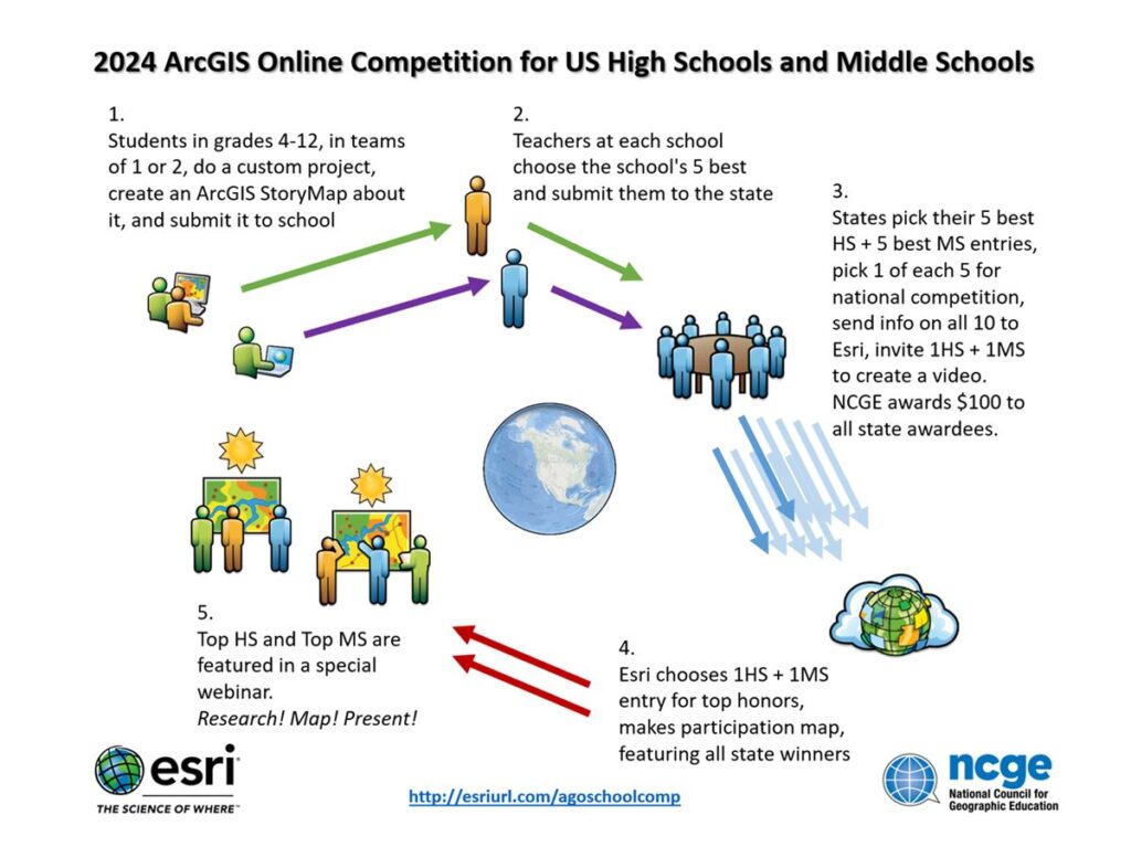
For Judges

JUDGING CRITERIA
A panel of GIS professionals and educators will use the rubric below to determine the point value awarded to each submitted story map. There is a possible total of 100 points. This same rubric should be used to judge the maps at the school level to determine the best five to submit. (A pdf copy of the rubric can be accessed at bottom of this page.)
Design/Judging Criteria
- Entries should be analytical in nature, map-centric rather than photo-centric.
- Entries must be visible without requiring a login. Entries engaging "premium data" (login required, such as Living Atlas) must set up the display to permit access without needing a login. See helpful note.
- Entries must be "original work by students," but may use data generated by outside persons or institutions, within guidelines of "fair use." (Students are encouraged to use appropriate professionally generated data, but the integration, treatment, and presentation must be original.)
- Entries must provide two links in "short URL"format (e.g. http://arcg.is/1A2b3xyz), one linking to the item details page and one linking to the display page (The Story Map itself).
- The rubric for judging the state map submissions is based on the national scoring rubric. The rubric will apply to all entries regardless of grade level. (100 points)
Topic (5 points): The topic is clearly stated and addresses an aspect of the students' home town. Topic ideas include: interesting/ significant historical events, trends or changes related to topics such as immigration, agriculture, environment, education, transportation and government within the borders of their hometown.
Map Presentation (10 points): The student has effectively used the story map format to tell a "Hometown, Illinois" geographic story.
Cartography (20 points): The basemaps, layers and views used are extremely effective in presenting all the critical elements of the topic and story.
Data (15 points): The data selected is appropriate to tell the story, includes the most important elements, does not leave out any obviously important elements, and does not include irrelevant elements.
Student Created Data (5 points): Five points are set aside to specifically reward students who create important data for their story map. Data created by the student should be documented on the Details page. Points awarded from 0 to 5 based the significance of the data created.
Geographic Analysis (20 points): The student effectively used at least one type of geographic analysis to present the story. Here are some possible types of analysis:
- Classification: Data is presented using some form of classification such as population density, median income, etc.
- Symbolization: The data has been symbolized by shape, color or size.
- Filtering: Data has been filtered to show specific characteristics.
- Geoanalysis: The geographical distribution of the data has been analyzed and the pattern explained.
Documentation (25 points): Documentation in the item details page is clear and complete:
- All non-original contents (images, videos, text) in the story map are appropriately referenced and/or linked.
- Original contents are described and/or linked.
- Documentation identifies processes used to analyze the content.
- All persons who assisted in project are identified (including specifying if no one did).
For State Organizers
State to Esri (Microsoft Excel)
State organizers fill out this form and submit it to Esri