
 The open data movement is for everyone, by everyone. Open data provides a rich source of freely available information to make good decisions and understand the world. The key to this movement is crowd-sourced data – data gathered from a “crowd”. The crowd could be everyone in the world or a local group.
It’s exciting and empowering to have the tools and information to access and contribute to this body of knowledge. Through participation in the “Do-It-Yourself Geo Apps” MOOC by Esri, I learned about open GIS data that is available for use in map projects. To access a treasure trove of GIS data visit http://opendata.arcgis.com/. No login is required to explore and download the data. However, an ArGIS Organization account is required to contribute or share your data. Through the ConnectEd Esri Initiative teachers may request an ArcGIS Online Organization account for their schools.
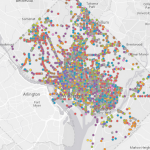
The following link will take you to an example of a map created with open data. http://goo.gl/h2kXaC. Following step-by-step directions provided for an exercise in the Do-It-Yourself Geo App MOOC, I created a map app for pedestrians in the Washington DC area. This is a great example of the power of crowd-sourced data.
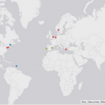 If you would like to contribute to a crowd-sourced map visit http://goo.gl/WJfDgL. The link will take you to a short 2 question survey asking how many languages you speak and what the languages are. The results of the survey are displayed on a world map. This survey was also created for an exercise in the Do-It-Yourself Geo Apps class.